Welcome to Billings!


Billings is located in the west-central area of the state and south of Montana within the Yellowstone County. It's located near the Rocky Mountain's eastern edge and on the Yellowstone River. It's the state's largest city! It's located in a very well irrigated area, and an important point where trade and shipping takes place. 

Ch. 1 Regions and Ecoregions: An Approach to Sustainable Geography

Billings' ecoregion is considered within the Temperate Steppe Division or the Great Plains. The Yellowstone River flows toward northeast along the east side of the city. Billings and Yellowstone County are the most greatly populated area in Montana. The land area of the city is 39.6 square miles, while the county is 2,646 square miles. The elevation of Billings is 3,567 feet above mean sea level. It contains both plains and mountain geographies. In the north and east, the landmark border called the Rimrocks are formed by the 300 to 500 feet sandstone cliffs. The land above the Rimrocks are rolling hills with sandy and clay loam soils. In the south, the hills are steeper with high and flat tablelands.

Ch. 2 The Nonhuman World: Understanding the Limits

Billings’ physical landform is the Interior Plains. It's located in the fertile Yellowstone River valley with three mountains around its area. The mountain helps lessen the city from harsh cold weather during winter. One of the nearest mountains is the Absaroka-Beartooth Mountains. While some moist air is being carried from the Pacific Ocean, it’s called the “Chinook winds”. It helps lessen the extreme hot and cold weather in the city.

The climate in Billings is semi-arid. Summers are very hot, and winters are both dry and cold. During summer, the temperature could get over 100 degrees Fahrenheit but usually 73 degrees Fahrenheit average. The winter could be as low as -38 degrees or 23 degrees Fahrenheit average with around some average of 57 inches of snowfall per year. Spring and fall are very short seasons in Billings, but often unpredictable weather. Actually, it’s considered mild in the northern area. The precipitation of Billings is around 14 inches per year.

Agriculture is an important part of Billings’ economy and their number one industry. Around 20,000 to 74,999 acres of wheat were harvested in the Yellowstone County in 2002, but not enough precipitation to grow corn. Therefore, oats are their replacement for corn. Billings’ primary crops include oats, alfalfa, and sugar beets. Crops like oats often grow better in a moister and cooler area. The soil that needed to grow oat is silt and clay-loam soils. The oat are usually not made or transported for human food, since its costs are low. It’s usually used primarily on making hays and feeding livestock. In the other hand, Billings produce sugar beets and sell it for millions of dollar per year. Especially during the fall, it’s full of the sweet sugar smell sweeps across the city that’ being carried along with the cool air. 

The sandy loam soils are rich and good natural drainage, especially on the higher area. The amount of surface water in the city is 0.275 square kilometers. The Billings Canal could be used for irrigation. But it has better agricultural land than water to irrigate it; it would require more water storage in non-irrigating seasons. The groundwater could not be used because the coals are too deep below the surface. Also the groundwater from the coals usually contains salinities, which is not suitable for agriculture and domestic use. 

There were climate changes, and it’s predicted that it would be a bigger change in the future. Places in planting vegetation would have to be moved to a higher area on the mountain. There is increase in precipitation, and the rate of precipitation change is 10 to 20%.
Natural disasters in Billings include hail storms that could destroy crops. There are occasional tornados, but there is no volcano or earthquakes. 

Ch. 3 Sustainability: Redefining Progress

The resource and energy use in Billings is by creating homes that could help conserve energy. They are large windowless buildings, but also a pretty disfigured home in the city. But it is also the most energy-efficient building in the nation. It is useful especially in dry climates. They design the building at downtown in a way that could get exposure from the sun with clerestory monitors and photo-voltaic panels. The skylights being exposed on the roof framing creates energetic lit galley and reception space. 


By reducing the use of fossil fuel, they reduce the need for more energy. They would gather the energy from daylight using the roof, walls, and windows, while reducing the heat transfer into the building. The remaining energy can be used for radiant floor heating, evaporate cooling, and daylight sensors. It creates more renewable sources, and 10 kilowatt photo-voltaic system contributes to 50% more electricity every year. The fossil fuel energy is then reduced to 19%.


They also make use of waterless toilets, and 60% of water can be saved up throughout the building. The other way they do to reduce the use of water is by planting drought-tolerant plants. Other reusable resources are recycled glass paving, which is suitable for its climate because it makes easier to remove storm water, alleviate urban heat island effect, and lessen the wattage for parking lights.


GHG emissions included CO2, CH4, N2O, and CO2e from both gas and oil wells own by federal and non-federal governments. As for CO2, Billings’ is predicted to have a total of 21,007 metric tons per year. CH4 is 158.1 metric tons per year. N2O is 0.103 metric tons per year. CO2e is 22,105.1 metric tons per year.

Carbon pollution from power plants had been addressed by Obama recently that coal mining should be stopped to prevent further climate change. A new pollution standard should be created for the power plants. Then environmental organization said that it should be made into renewable fuels and never run out. Montana is ranked as the sixth in coal production within America.
http://www.usgbcmontana.org/northernplainsresourcecouncil.html

Ch. 4 Population and Consumption: Quantity versus Quality

Billings has always been the most populated city in Montana. The total population of Billings is around 106,954 in 2012. During 2000, 57.2 % of the population were born in the state and the population density was 2,656 people per square mile. A year from July of 2002 to 2003, the city have had a population increase of 1.4 percent. It has been steadily increasing from 1990 till 2012, which in 1990 are 81,537 people. The population growth of Billings is 14.35 percent from 2000 till 2012.

The ethnic component of the city during 2010 is 89.6% White, 5.2% Hispanic, 4.4% Native American, 0.8% African American, 0.7% Asian, 0.1% Pacific Islander, and 1.4% from other races. Billings consists mostly White people.

The age population from 65 years old and over during 2010 is 14.98%. Adults from 18 to 64 years old are 62.41% during 2010. Children from 5 to 17 years old are 15.60% and from 0 to 4 years old are 7.00%.  The largest age group’s population are adults from 18 to 64 years old, while infants to 4 year old children have the least population.


From 2000 to 2010, elderly above 65 years old have increased by 17%. Adults from 18 to 64 years old have increased by 18.39%. Children from 5 to 17 years old have increased by 3.48% and from 0 to 4 years old increased 23.99%. All of the age groups’ population have increase, but infants to 4 year old children have increased the most.

Ch. 6 The North Atlantic Provinces and Northern New England: New Economic Hopes

Billings was founded in 1882 during the Northern Pacific Railroad building time. It started with almost no building. But after the railroad had been built within a few months, it settled more than 2000 buildings. Not long after, there is also the discovery of oil fields, great natural gas and coal reserves. Minerals, coal, natural gas, and oil are Billings’ natural resources. It was once a large trading point for wool throughout the nation. The energy companies’ headquarters are in Billings. During 1910, Billings became the 6th most rapid growing community in the country. The population at that time was 10,031.

This is what Billings looks like during 1915:

The Billings Canal that was the irrigation canal was built in 1900s that plays an important part for supporting the economy now days because it provides necessary irrigation for farmers and residents.  After 1945, the city had a rapid growth in financial, medical, and cultural center, which the growth rate was at 66 percent at that period. During 1975 to 1986, the coal fire generation plants were created. Within that period, there was more growth in Billings so the high-rise buildings were built. The large prairie land is suitable for feeding and raising livestock. People started moving in during the 1900s and start their own farmland. There were immigrant laborers that move there to work on the fields, such as the Japanese, Russo-Germans, and then Mexicans. The industry grew and the population increase. 

Ch. 7 Megalopolis: Setting Sustainable Standards

The Billings Metropolitan Statistical Area is the largest metropolitan area that includes both Yellowstone County and Carbon County just below it. Its total population is 160,097 people. The city is surrounded by the rivers, lakes, and trees within the prairie. If out of the town, there is basically short in supply, which is not suitable for building a city. Since Billings is the largest city in Montana, it should be the most urban place comparing to other cities in Montana including their business, transportation and sales center  It’s also an important area for trading and distributing. It is a retail and wholesale business area that requires no sales tax. There are not much tall buildings in Montana, but Billings contains the only high-rise buildings in the state. The First Interstate Tower is the tallest building that’s 20 stories high in Billings, Montana. 


The major industries that help the growth of their economy are their agriculture, energy, transportation, health care and education. Billings have large oil and natural gas fields. It have three oil refineries, a coal fire generation plant, a sugar beet refining plant, and many other services  including mining are all one of things that support their economy. The main headquarters in the state are all located in Billings as well.

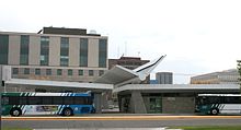
There is a main Interstate highway on the city and it comes all the way from the east side of Montana, and the city often gets lots of traffic due to the highway. Another main highway near the city is the 90 highway, which is also makes a nice stopping area for most visitors. Their public transportation is buses, and there are trail systems that go all over the metro area. They also have their own airport.


Their cultural activity and shopping center is what attracts visitors from places. It is also a suitable place to stay when visiting nearby park like Yellowstone National Park, Glacier National Park, or other mountains, which is what most visitors did. Visitors could ski, fish, bike, visit museums, rodeo, and food fairs.
                        
http://en.wikipedia.org/wiki/Billings,_Montana

Ch. 8 Appalachia: Trying to Love the Mountains

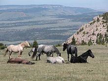
Billings is divided by the Rims and cliffs. It’s located in the downtown’s north and east part and separated the Heights that’s 500 feet tall and Lockwood that’s 800 feet tall. The city’s total area is 43.52 square miles, while 43.41 square miles are land and 0.11 square miles are water. The city is surrounded by six mountain ranges and can be seen from the city. One of them is the Bighorn Mountains, and it’s around 13,000 feet tall. It contains more than 200 lakes. The other one is Pryor Mountains, where the wild horse range is. Another mountain is the Beartooth Mountains, which is the highest area in Montana. Another mountain is the Big Snowy Mountains, where there is a Crystal Lake. Another mountain is the Bull Mountains; it’s located at the north of Heights and positioned in the low heavy forested range. The other mountain is the Crazy Mountain.


Billings have the largest coal reserves within the U.S. There are twelve coal mines in Montana. Coal mining in Bull Mountain started around the 1800s. There is an underground coal mining area called the Signal Peak Mine. But it was being shut down during 2011 due to the great amount of carbon monoxide found within the mine. Soon after that, nitrogen is being added into the mine to reduce the gas to the safety standard. In 2007, it’s estimated that 12.5 million tons were being produced. 

Ch. 9 South Atlantic: Gentry Tidewater, Hardscrabble Piedmont, and the Northern Invasion of Dixie

Billings’ culture and heritage contain the indigenous people’s culture as well, and they are called the Crow. There were about 10,603 to 12,000 tribe members living in the Yellowstone and Big Horn counties. They search throughout the Great Plain for the tobacco plant, and it’s found in the east side of the Big Horn Mountains. It is also included in the Louisiana Purchase land, and then Louis Clark explored the land. Soon, White people settled the land.

The oil industry in the city is sprawling as well. Since Alberta in Canada is near Billings, the pipelines were built in Billings and oil is being given out through the nation’s market. Employment is being reduced due to efficient technology in oil production. The oil production's value is higher than copper mining.